Iceland, known for its dramatic landscapes — glaciers, volcanoes, lava fields, and geothermal wonders — is once again under global attention, as a renewed cycle of volcanic activity intensifies across the Reykjanes Peninsula. What began as striking geological phenomena, drawing scientists and tourists alike, has gradually become a pressing matter for local communities, infrastructure, and everyday life. The recent years show that this is not a short, isolated episode but potentially the beginning of a long‑term, active geological era.
The Awakening: Dormancy Ends
For centuries, the Reykjanes volcanic system lay quiet. It had been some 800 years since any substantial eruptions were recorded in certain parts of the peninsula. Iceland’s position astride the Mid‑Atlantic Ridge means tectonic forces are continually at work — two large plates (North American and Eurasian) slowly pulling apart, magma rising, crust forming — but often, much of this activity is underground, unseen.
Then, starting about 2021, signs of life began to reappear. Eruptions broke out, initially in remote locations far from human settlements, giving scientists early warning of what might come. But over time, the pattern shifted: seismic tremors, magma accumulation, and fissures opening closer to inhabited areas.
Increasingly Close to Home: Risk to Grindavík
One of the towns most affected is Grindavík, a fishing community on the southern side of the Reykjanes Peninsula, with roughly 4,000 inhabitants before recent evacuations. As volcanic activity intensified, Grindavík was placed on high alert.
In late 2023, ground‑sensors, satellite imagery, and tremor monitoring showed magma building up beneath the area surrounding Grindavík. This prompted authorities to issue a full evacuation order for the town, precautions that proved critical.
Eruption Events & Their Impacts
Here is a summary of the eruption cycle, especially from 2023 through mid‑2025, along with their direct and indirect effects.
-
December 2023: A fissure eruption roughly 4 kilometers northeast of Grindavík. Short in duration (a few days). It changed the lava’s trajectory enough to signal risk for residential zones.
-
January 2024: New fissure activity in the same crater chain. Lava reached the outskirts of Grindavík and destroyed three homes — but because of evacuation, there were no injuries. This was a major psychological blow, as the lava threatened the town’s edge.
-
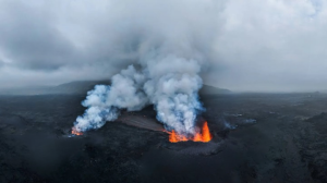
Through 2024: Multiple eruptions in the Sundhnúkagígar crater row. These included events in February, March‑April, May, August, November‑December. Some lasted just a day or so; others for many weeks. Each time, lava flows, fissures, gas emissions, and the unpredictable behavior of lava raised alarms for safety and logistics.
-
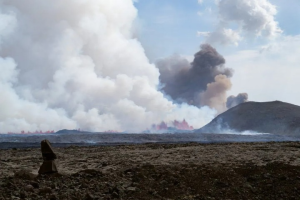
April 2025: Another eruption at the Sundhnúkagígar fissures. It breached a protective barrier north of Grindavík. Evacuations were ordered, including of tourists in nearby spas (notably the Blue Lagoon), campsites, etc.
-
July 16, 2025 – Early August 2025: The most recent significant eruption (as of early October 2025). A fissure 700‑1000 meters long opened southeast of Litla‑Skógfell, and lava flowed from Sundhnúkagígar. The eruption lasted until about August 5. Although the flow was away from major populated areas, the risk was still real — precautionary evacuations were again carried out.
How Iceland Is Managing the Threat
Recognizing that this is no longer a remote risk, Icelandic authorities have put in place several measures to protect people and property, and to prepare for future eruptions. Some of the major efforts:
-
Monitoring and Early Warnings
The Icelandic Meteorological Office (IMO) uses seismic sensors, GPS for ground deformation, satellite imagery, and even drone mapping. When magma moves beneath the surface, or when there are rapid ground uplift events, those tools give early signals. Authorities also issue SMS alerts to residents when seismic thresholds are crossed. -
Evacuations & Precautionary Measures
Towns near susceptible areas (especially Grindavík) have been evacuated multiple times. Tourist attractions like the Blue Lagoon spa have likewise been shut down during active crises. Protective infrastructure (lava barriers) have been constructed, and existing ones reinforced. Road closures, hazard zone delineations, and restricted access to eruption sites are standard during high‑danger periods. -
Infrastructure Resilience
Physical defenses have been built or strengthened. For example, protective barriers around Grindavík and the Svartsengi power plant area have been made higher. Eruptions that threatened roads, pipelines, utility infrastructure triggered repair operations and rerouting. There are also efforts to fund these defenses through additional levies (such as property or insurance based taxes) so that the cost is shared and sustainable. -
Public Communication & Safety Guidelines
Information to residents and tourists is shared via multiple channels: government websites, tourism boards, media outlets, and signs in hazard zones. Warnings about gas emissions, dangerous heat, unstable ground, and falling ash are emphasized. People are asked to keep distance, to watch for evacuation orders, and to follow the instructions of local authorities. -
Tourism & Travel Management
Despite eruptions, airports (like Keflavík) have largely remained operational. Travel advisories are issued when needed. Many parts of Reykjanes are safe; others are closed off temporarily. Tourists are often advised to avoid certain roads or viewpoints if conditions are unsafe. The Blue Lagoon has had periodic closures. Tourist infrastructure and services continue, but with caution.
Why This Cycle Is Different
Several factors make the current Reykjanes eruptions more challenging (and more significant) compared to earlier volcanic episodes in Iceland.
-
Proximity to Populated Areas: Unlike many earlier eruptions that occurred in remote highland regions, many recent fissures are much closer to towns like Grindavík, or near critical infrastructure (e.g. power plants, spas, tourist sites). This raises risk levels.
-
Frequency & Pattern: Since 2021, there have been many eruptions in the Reykjanes Peninsula: each fissure event somewhat distinct, but connected through underlying magma systems. There’s also been consistent seismic activity and ground deformation. This is not a one‑off eruption, but a sequence, sometimes called the “New Reykjanes Fires.”
-
Long‑term Magma Build‑up & Geological Time Scales: Scientists see that magma is accumulating in underground chambers, and that episodes of uplift and tremors suggest ongoing pressure. The geological record says such cycles can persist for decades or even centuries. It means repeated eruptions, repeated disruptions, and persistent risk.
-
Visibility & Tourism: Because the region is famous for its geothermal attractions — Blue Lagoon, lava fields, hiking routes — the eruptions attract attention. That both increases risk (more people near danger zones) and opportunity (tourism, education). But managing both safely is a delicate balance.
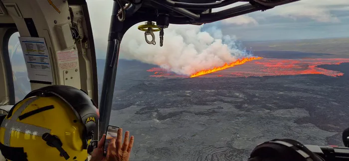
Recent Eruption: July 2025 Case
The eruption that began around July 16, 2025, is one of the more vivid examples of modern erosion of safety margins, and how well‑prepared (or strained) systems are coping.
-
A fissure between about 700‑1,000 meters opened near the Sundhnúkagígar crater row, southeast of Litla‑Skógfell mountain. Lava flowed from this fissure.
-
Precautionary evacuations were made: Grindavík residents were evacuated, the Blue Lagoon spa and nearby campsites closed.
-
The eruption lasted until about August 5, 2025, after which visible lava flow ceased. But hazards remained: new lava fields, hot crusts, risk of gas pollution, unstable ground.
This eruption was important not just for its visual drama, but for what it revealed about preparedness, risk tolerance, and how society responds when geological forces approach human settlements.
The Human Cost & Community Effects
While no reports (so far) show major loss of life during these recent cycles, the impact on human communities is real and multifaceted.
-
Displacement: Many Grindavík residents have been evacuated, often more than once. Homes, businesses, services may become inaccessible. Some may be damaged or destroyed by lava or ground deformation.
-
Economic Impact: Tourism is a major part of Iceland’s economy. While many areas remain open, attractions near active zones (Blue Lagoon, certain hikes) are periodically closed, which disrupts income. Infrastructure damage (roads, pipeline, power facility) adds cost.
-
Psychological Stress: Living under threat of eruption, hearing alarms, watching fires of lava creeping near, gas plumes, uncertainty — all contribute to stress, fear, and anxiety. The possibility that your town might need evacuating again becomes part of life.
-
Environmental & Health Concerns: Gas emissions (sulfur dioxide, other volcanic gases) can affect air quality; lava flows destroy vegetation and cover land; new lava fields are unstable and dangerous.
-
Infrastructure Threats: Protective barriers are costly; construction and reinforcement take time. When lava breaches or approaches roads, power plants, pipelines, they risk damage. Sometimes these barriers succeed; other times they are tested close to breaking.
Science, Prediction, and Uncertainty
Volcanologists and geologists are closely monitoring many indicators to predict and manage risks:
-
Seismic Activity: Earthquake swarms often precede eruptions. Monitoring frequency, magnitude, depth helps estimate what might come.
-
Ground Deformation / Uplift: When magma pushes upward, the ground often bulges. GPS and satellite radar (InSAR) detect that.
-
Gas Emissions: Increased gases from the earth (sulfur, CO₂) can indicate magma near the surface.
-
Thermal Imaging & Satellite Observations: Hot spots, changes in surface temperature, new cracks or fissures.
Even with all these tools, there remains substantial uncertainty. Eruptions may happen with little warning; fissures may open unpredictably; flows may change direction. Lava barriers may divert flows, but only somewhat.
What the Future May Hold
Based on current observations, expert projections, and geological history, several things appear likely in the medium to long term (years to decades):
-
More Eruptions, Perhaps More Frequent
The pattern since 2021 suggests that Reykjanes will remain volcanically active. New fissure eruptions are expected. Some will be relatively small and contained; some may be more disruptive. -
Ongoing Risk to Grindavík and Neighboring Settlements
Given magma build‑up, proximity of fissures, and repeated breaches of protective barriers, Grindavík remains vulnerable. Residents may need to remain willing to evacuate, and infrastructure must be reinforced. -
Continued Infrastructure Investments
More and higher lava diversion walls, reinforcement of existing ones, planning of evacuation routes, improved emergency services capacity. Risk mitigation will be a long‑term project. -
Balancing Tourism & Safety
Iceland’s appeal includes its volcanic landscapes; many tourists want to view eruptions or lava fields. But safety will likely require more guided access, closure zones, viewing platforms, and perhaps regulations on how close people can approach eruption sites. -
Climate & Environmental Effects
Over time, repeated eruptions alter the land: new lava fields, destroyed vegetation, changed hydrology. Air quality impacted during eruptions can have health effects, both immediate (gas inhalation, volatile sulphur compounds) and perhaps longer term. -
Learning & Adaptation
Local authorities, scientists, civil protection, and communities are learning: which protective barriers work, how quickly to evacuate, how to communicate effectively, how to rebuild. These adaptations will be crucial.
Recent Data & Timeline Highlights (2021‑2025)
To understand how this eruption cycle has unfolded, here are key events and metrics:
| Date / Period | Event / Feature | Significance |
|---|---|---|
| 2021 | First signs of reactivation after centuries; remote eruptions begin | Break from long dormancy; scientists notice unusual activity |
| Late 2023 | Seismic swarms, magma accumulation under Grindavík; first major evacuation orders | Town facing direct risk; defenses tested |
| December 2023 | Eruption ~4 km NE of Grindavík; early warning works | Evacuation saves potential lives |
| January 2024 | Fissure reaches outskirts; destruction of three homes; evacuation prevents casualties | Infrastructure near boundary; threat becomes real |
| Various dates in 2024 | Multiple eruptions at Sundhnúkagígar, other fissure rows; some last weeks | Shows persistence and unpredictability |
| November‑December 2024 | Barrier breaches; damage to parking lots, road access; investment in barrier height increases | Infrastructure under strain; defensive measures ramp up |
| April 2025 | Eruption breaches protective barrier; evac of Blue Lagoon & Grindavík | Safety measures tested; tourist infrastructure impacted |
| July‑August 2025 | Fissure 700‑1,000 m; lava field; lasts until early August | Recent major event; showcases current risk and capability to respond |
What Can Be Learned / Lessons
From this active volcanic era, several lessons emerge, useful not only for Iceland but for any region facing geological risk.
-
Early Warning Systems Are Essential: Monitoring for seismic and deformation signals can buy critical time. Evacuations are most effective when done early.
-
Preparedness Matters: Town planning, evacuation protocols, strong emergency services, resilient infrastructure (barriers, roads, communications) reduce damage.
-
Communicating Risk Clearly: Authorities must clearly inform residents and visitors about potential hazards, closures, and how to stay safe. Miscommunication or delays worsen damage or risk.
-
Flexibility & Adaptation: Because volcanic behavior is unpredictable, responses must be flexible. Protective measures may need adjustments; evacuation zones may change; new fissures may open.
-
Balancing Human Use & Natural Forces: Tourism, local livelihoods, homes, and power plants are all part of human development, but they must be planned with risks in mind. Protective installations (lava diversion walls, more robust barriers), buffer zones, land use planning are vital.
-
Long‑Term View: Geological time is longer than human political/governmental cycles. Funding, maintenance, research must be sustained over long periods, not just immediate crisis phases.
Safety Advice & What to Do If You’re in the Area
If you live in, plan to visit, or are generally interested in the Reykjanes Peninsula, or any region with volcanic activity, here’s what to keep in mind:
-
Stay informed via official sources: Icelandic Meteorological Office (IMO), government safety agencies, local news outlets. Check for updates before traveling or before doing outdoor excursions.
-
Obey evacuation orders immediately. They are based on scientific and safety assessments. Do not try to wait it out.
-
Keep away from recent lava flows: new crust may hide molten lava underneath; surfaces may collapse.
-
Be aware of gas danger: volcanic gases can be toxic, especially for people with respiratory issues. During active eruptions, avoid low‑lying areas where gases accumulate.
-
Prepare logistics: know your routes, where shelters are, have supplies in case of displacement.
The Broader Implications
This eruption cycle has implications beyond Iceland’s shores:
-
Scientific Knowledge: Each eruption adds understanding of magma plumbing, fissure behavior, how lava flows interact with geography and human infrastructure. This knowledge benefits volcanology globally.
-
Climate & Atmosphere: While current eruptions at Reykjanes are mostly fissure types that don’t blast huge amounts of ash into the stratosphere, repeated eruptions over time could contribute more atmospheric gases, aerosols, etc., which can influence air quality and climate locally.
-
Tourism Models: Destination safety, sustainable tourism, risk communication become more critical. The balance between allowing visitors and protecting people and resources becomes more delicate.
-
Urban & Infrastructure Planning: Regions with active geology must factor risk into zoning, construction codes, land use. Being resilient to natural disasters is not extras — it’s essential.
-
Disaster Preparedness Globally: The way Iceland is handling these challenges — through monitoring, evacuations, public education, infrastructure defense — offers a potential model for other volcanic regions around the world.
The Present Situation & What to Watch Next
As of early October 2025, key facts:
-
There is currently no visible eruption ongoing in Reykjanes. The most recent one (started July 16, 2025) has ended, though the area remains under watch.
-
Monitoring shows intermittent tremors and ground deformation — signs that magma is still moving underground. Potential for new fissure eruptions remains.
-
Airports are operating normally; major travel routes remain open. Tourist activities continue in many areas, though restrictions apply near recently active zones and eruption sites.
What people should watch for:
-
New seismic swarms: increase in earthquakes often signals magma movement.
-
Ground uplift / deformation: bulging of earth, cracked ground, shifts in elevation.
-
Gas emission warnings: detection of sulfur dioxide or other volcanic gases.
-
Government advisories/evacuation alerts.
Conclusion: A New Era
The Reykjanes Peninsula is no longer a dormant volcanic frontier. It has entered a renewed era of activity. What makes this significant is not only the eruptions themselves, but how they are unfolding: closer to human settlements, more frequent, unpredictable, with impacts on daily life, infrastructure, tourism, and economy.
Iceland has so far responded with seriousness, preparedness, scientific monitoring, and citizen involvement. Protective structures have been built, evacuation plans are repeatedly tested, and communication systems are in place. Still, the scale of the challenge is large. The geological forces here are ancient, powerful, and indifferent.
For residents, tourists, and governments, the Reykjanes Peninsula stands as both a warning and an opportunity. A warning that nature’s power does not wait, and an opportunity to build resilience, to learn, to adapt, and to live in closer harmony with the earth beneath our feet.
This cycle of eruptions may stretch on for years or even centuries. But Iceland’s people, and those who visit, are quietly showing that human resolve, science, and careful planning can coexist with fire, ice, and molten earth.