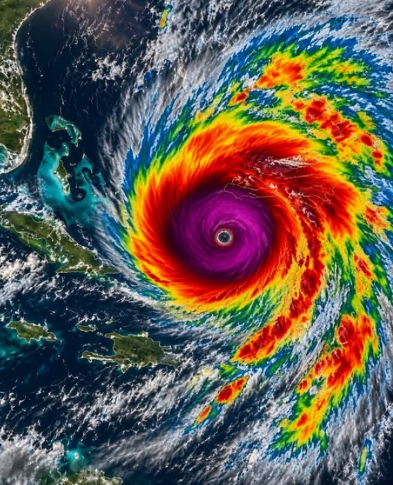
A dramatic satellite image showing a massive hurricane over the ocean has been circulating online, attracting attention and raising concerns about another major storm approaching the Caribbean.
The image features a clearly defined eye surrounded by spiralling clouds and brightly coloured areas representing atmospheric activity. Combined with a headline claiming that Hurricane Melissa is forming, it may appear to show an immediate weather threat.
However, the headline is misleading.
Hurricane Melissa was a real and exceptionally powerful Category 5 hurricane, but it developed in October 2025. It is not a new storm forming in November 2026. Its name was officially retired in March 2026, meaning it will not be used again for another Atlantic hurricane.
According to the National Hurricane Center’s October 30, 2026 update, there were no active tropical cyclones in the Atlantic at that time.
Although the viral claim is inaccurate, Melissa’s history remains important. The hurricane caused devastating damage across parts of the Caribbean, particularly Jamaica, and demonstrated the destructive potential of an exceptionally powerful tropical system.
The Satellite Image That Brought Attention Back to Hurricane Melissa
Satellite images can provide a remarkable view of hurricanes from space. They show how clouds and thunderstorms organize around a storm’s centre and allow meteorologists to monitor changes in its structure.
In the image circulating online, a large spiral of clouds surrounds a clearly visible central eye. Bright colours highlight different atmospheric measurements, depending on the satellite product being used.
The image is associated with Hurricane Melissa, which became one of the most powerful hurricanes recorded in the Atlantic basin.
The problem is the way the image has been presented. When an older photograph is shared alongside phrases such as “forming now” or “breaking news,” people may assume that the event is happening in real time.
This can create unnecessary concern, particularly among residents of hurricane-prone areas.
A satellite image alone cannot confirm that a new hurricane is developing. Its original date, location, and accompanying meteorological information must be checked.
The important distinction is that Melissa was a historic storm from 2025, not a new Atlantic hurricane developing in October or November 2026.
How Hurricane Melissa Reached Category 5 Strength
Hurricane Melissa became exceptionally powerful because several favourable environmental conditions came together over the Caribbean Sea.
Tropical cyclones obtain much of their energy from warm ocean water. As water evaporates, moist air rises into the atmosphere. When the water vapour condenses into clouds and thunderstorms, heat is released, helping maintain the storm’s circulation.
Warm water is important, but it is not the only factor that determines how strong a hurricane becomes.
Atmospheric conditions also influence whether a storm can organize and intensify.
The Importance of Warm Ocean Water
One important factor in Melissa’s development was the availability of unusually warm ocean water.
Ocean heat content describes the amount of heat stored beneath the ocean’s surface. This is important because a powerful hurricane can mix cooler water upward as it moves across the sea.
When warm water extends deeper below the surface, the storm may continue receiving energy even after disturbing the upper layers of the ocean.
The National Hurricane Center’s assessment identified high sea-surface temperatures and substantial ocean heat content as important conditions supporting Melissa’s intensification.
Wind Shear and Storm Organization
Another important factor is vertical wind shear, which refers to changes in wind speed or direction at different heights in the atmosphere.
Strong wind shear can disrupt a developing hurricane by tilting its circulation and separating thunderstorms from its centre.
Lower wind shear allows the storm to remain more organized, helping its circulation strengthen.
Melissa encountered favourable atmospheric conditions, including relatively low wind shear, which supported its rapid intensification.
As the storm developed, its thunderstorms became increasingly organized. Spiral rainbands formed around the centre, and a distinct eye became visible.
What Category 5 Means
The Saffir-Simpson Hurricane Wind Scale classifies hurricanes according to their maximum sustained wind speeds.
Category 5 is the highest classification. It applies to hurricanes with sustained winds of at least 157 miles per hour, or approximately 252 kilometres per hour.
Melissa reached estimated maximum sustained winds of approximately 185 miles per hour, equivalent to around 295 kilometres per hour.
Its minimum central pressure was measured at approximately 892 millibars.
These measurements placed Melissa among the most powerful hurricanes recorded in the Atlantic.
Such extreme winds can cause catastrophic damage to buildings, roads, electrical networks, vegetation, and other infrastructure.
However, a hurricane’s category does not describe every possible danger. Rainfall, flooding, storm surge, storm size, and forward movement can also determine how destructive a system becomes.
Jamaica and the Caribbean Experienced Devastating Impacts
The most severe consequences of Hurricane Melissa were experienced in the Caribbean, particularly in Jamaica.
On October 28, 2025, Melissa made landfall near New Hope in Westmoreland Parish as a Category 5 hurricane.
The storm crossed Jamaica from southwest to northeast, exposing communities to destructive winds, heavy rainfall, storm surge, and widespread flooding.
For residents, the consequences extended far beyond the weather conditions visible on television or satellite images.
Homes suffered serious damage, roads became difficult or impossible to use, and essential services were disrupted.
Strong winds can remove roofing materials, break windows, uproot trees, and bring down electrical lines. Flying debris can damage buildings and create additional risks for people caught outdoors.
Flooding can be equally dangerous. Heavy rainfall may cause rivers and drainage systems to overflow, while landslides can block roads and isolate communities.
The National Hurricane Center’s official assessment documented catastrophic impacts in western Jamaica and major disruptions to essential services.
Melissa also affected Haiti, Cuba, the Bahamas, and other parts of the Caribbean region.
Disruption to Healthcare and Essential Services
A major hurricane can affect communities even when residents are not directly injured by wind or floodwater.
Hospitals and health facilities may experience damage, electricity interruptions, or difficulties receiving medical supplies.
People who depend on regular medication or electrical medical equipment can face additional challenges when services are disrupted.
Access to clean drinking water, food, temporary shelter, and reliable communication also becomes especially important after a major storm.
The Pan American Health Organization reported severe impacts on Jamaica’s health services and coordinated regional support with health ministries and other partners.
The National Hurricane Center’s tropical cyclone report recorded 95 fatalities associated with Hurricane Melissa.
This figure demonstrates the seriousness of the disaster and the importance of preparing for all hurricane-related hazards, not only strong winds.
Recovery Can Take Years
Recovery after a Category 5 hurricane is often a long process.
Clearing debris is only one part of the work. Homes must be repaired, roads restored, electrical systems rebuilt, and schools and healthcare facilities returned to normal operation.
Families who lose their homes may need temporary accommodation while reconstruction takes place.
Small businesses can also face serious difficulties when buildings, equipment, and supply routes are damaged.
Agricultural communities may experience losses involving crops, livestock, and productive land, affecting household income and local food supplies.
The emotional effects can continue long after the storm has passed. People who have experienced a destructive hurricane may feel anxious when strong winds or heavy rain return.
Children, older residents, and people who depend on regular support services may face particular challenges during recovery.
Rebuilding therefore involves more than repairing physical structures. Communities also need restored services, reliable infrastructure, and long-term support.
Why the Name Melissa Has Been Retired
Hurricanes receive names through an international naming system coordinated by the World Meteorological Organization.
Names make it easier for meteorologists, emergency services, governments, and the public to communicate about tropical storms.
Atlantic hurricane names are normally reused according to rotating lists. However, a name may be retired when a storm causes exceptionally severe destruction or loss of life.
This prevents the same name from being assigned to another hurricane in the future.
That is what happened to Melissa.
On March 4, 2026, the World Meteorological Organization announced that Melissa had been retired from the Atlantic hurricane naming list because of the destruction and loss of life associated with the 2025 storm.
The replacement name selected was Molly.
The decision reflects the exceptional impact Melissa had on Caribbean communities.
Other well-known hurricane names, including Katrina, Sandy, and Maria, have also been retired following devastating storms.
The naming system is primarily designed to improve communication. A recognizable name helps people understand which storm is being discussed, particularly when several tropical systems are being monitored at the same time.
Retiring a name also prevents confusion between a historic disaster and a future weather event.
For people who experienced Melissa, the name will remain connected to the difficult period that followed the storm.
Is Hurricane Melissa Forming Again in 2026?
No. The claim that a new Hurricane Melissa is forming in 2026 is false.
The storm was a real Category 5 hurricane in October 2025, but its name was officially retired in March 2026.
Furthermore, the National Hurricane Center’s October 30, 2026 update reported no active tropical cyclones in the Atlantic basin.
This makes it important to check the context of dramatic weather photographs before sharing them.
An authentic satellite image can still be misleading when it is presented with an incorrect date or an inaccurate headline.
How to Check Whether a Hurricane Report Is Current
When a dramatic storm image appears online, consider several details before treating it as breaking news.
- Check the publication date: Find out when the original satellite image was captured.
- Identify the source: Look for information from recognized meteorological agencies.
- Check the storm’s location: A real hurricane image should include details about where the system was observed.
- Look for official warnings: Evacuation notices and storm alerts should come from the relevant local authorities.
- Compare multiple reports: Reliable weather information should be consistent with official updates.
The National Hurricane Center provides advisories and forecasts for the Atlantic and eastern Pacific basins.
Local meteorological services and emergency-management agencies also provide information about conditions affecting individual communities.
People should not make evacuation decisions based on a viral caption or an undated image. Official warnings and local emergency instructions should always take priority.
Important Lessons Hurricane Melissa Left for Future Storm Seasons
Although Melissa is no longer an active storm, its history offers important lessons for communities living in hurricane-prone regions.
The hurricane demonstrated how destructive winds, heavy rainfall, storm surge, and slow movement can combine to create a major disaster.
It also showed why preparation should begin before a hurricane approaches.
Prepare an Emergency Kit
Households should consider keeping essential supplies available before the beginning of hurricane season.
A basic emergency kit may include:
- Drinking water.
- Non-perishable food.
- Essential medication.
- A first-aid kit.
- Flashlights and spare batteries.
- A battery-powered or hand-crank radio.
- Important documents protected in waterproof packaging.
- Supplies for infants, older adults, and pets when needed.
People who depend on daily medication or electrical medical equipment should make additional arrangements before severe weather arrives.
Know Your Evacuation Route
Residents of low-lying coastal areas and locations vulnerable to flooding or landslides should understand their evacuation options before a storm develops.
Family members should know where they can go and how they will contact one another if mobile networks or electricity become unavailable.
When authorities issue an evacuation order, residents should take it seriously.
A Category 5 hurricane can produce conditions that make remaining in an exposed building extremely dangerous.
Understand the Danger of Storm Surge
Storm surge occurs when powerful hurricane winds push seawater toward the coast, causing water levels to rise above normal conditions.
It can rapidly flood low-lying communities, damage buildings, and make roads impassable.
People sometimes focus mainly on wind speed because it determines the hurricane’s category. However, storm surge can be one of the most dangerous parts of a tropical cyclone.
Residents in coastal areas should follow evacuation instructions and avoid waiting until water begins rising before moving to safety.
Never Walk or Drive Through Floodwater
Floodwater may conceal damaged roads, open drains, debris, electrical hazards, and strong currents.
Even water that appears shallow can create serious dangers.
After a hurricane, residents should also avoid fallen electrical wires and damaged buildings. Structures may be unstable, and floodwater may contain sewage or other harmful materials.
Follow official instructions before returning to damaged areas.
How Modern Technology Helps Track Hurricanes
Modern weather forecasting relies on several sources of information.
Satellites provide observations of cloud patterns, storm organization, and atmospheric conditions.
Aircraft observations, ocean buoys, radar systems, and computer models provide additional information that helps meteorologists understand how a tropical cyclone is developing.
Forecasts can estimate a storm’s likely direction, intensity, rainfall, and potential coastal impacts.
However, forecasts always contain some uncertainty. A hurricane may change direction, strengthen, weaken, or move more slowly than initially expected.
This is why residents should follow updated official advisories instead of relying on a single forecast map shared online.
Improved forecasting and communication can provide communities with valuable time to prepare, but accurate information must reach people before conditions become dangerous.
Building More Resilient Communities
Melissa also highlighted the importance of long-term planning.
Rebuilding homes and roads exactly as they existed before a disaster may leave communities vulnerable to future storms.
Stronger construction standards, improved drainage, resilient electrical networks, accessible shelters, and careful coastal planning can help reduce the damage caused by future hurricanes.
Scientists also continue studying how ocean temperatures and atmospheric conditions influence tropical cyclone development.
Warmer ocean waters can provide additional energy for hurricanes, although other environmental factors also determine how individual storms develop. It would be inaccurate to attribute every particular hurricane directly to climate change without examining the available evidence.
For Caribbean communities, practical preparation remains essential. Protecting vulnerable residents, strengthening infrastructure, maintaining emergency services, and improving public communication can all help reduce future risks.
Remembering Melissa Without Spreading False Weather Alerts
The viral satellite image deserves attention because it is connected to a real and devastating hurricane.
However, the claim that Hurricane Melissa is forming again in 2026 does not reflect the facts.
Melissa reached Category 5 strength in October 2025, caused catastrophic damage in Jamaica and other parts of the Caribbean, and was officially retired as an Atlantic hurricane name in March 2026.
The National Hurricane Center reported no active Atlantic tropical cyclones in its October 30, 2026 update.
The distinction between an old image and a current weather warning is important. Misleading posts can create unnecessary fear and make it harder for people to recognize genuine emergency information.
Hurricane Melissa’s lasting significance is not the dramatic image circulating online. It is the communities affected, the lives lost, the recovery efforts that followed, and the lessons that can help protect people during future hurricane seasons.
Remembering the storm accurately is one way to respect those who experienced it and encourage better preparation for the future.